PDF Publication Title:
Text from PDF Page: 022
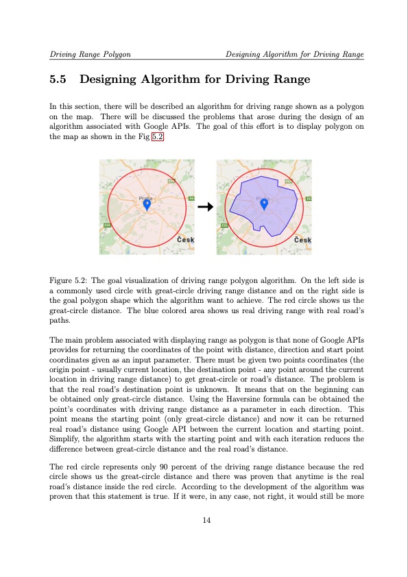
Driving Range Polygon Designing Algorithm for Driving Range 5.5 Designing Algorithm for Driving Range In this section, there will be described an algorithm for driving range shown as a polygon on the map. There will be discussed the problems that arose during the design of an algorithm associated with Google APIs. The goal of this effort is to display polygon on the map as shown in the Fig 5.2. Figure 5.2: The goal visualization of driving range polygon algorithm. On the left side is a commonly used circle with great-circle driving range distance and on the right side is the goal polygon shape which the algorithm want to achieve. The red circle shows us the great-circle distance. The blue colored area shows us real driving range with real road’s paths. The main problem associated with displaying range as polygon is that none of Google APIs provides for returning the coordinates of the point with distance, direction and start point coordinates given as an input parameter. There must be given two points coordinates (the origin point - usually current location, the destination point - any point around the current location in driving range distance) to get great-circle or road’s distance. The problem is that the real road’s destination point is unknown. It means that on the beginning can be obtained only great-circle distance. Using the Haversine formula can be obtained the point’s coordinates with driving range distance as a parameter in each direction. This point means the starting point (only great-circle distance) and now it can be returned real road’s distance using Google API between the current location and starting point. Simplify, the algorithm starts with the starting point and with each iteration reduces the difference between great-circle distance and the real road’s distance. The red circle represents only 90 percent of the driving range distance because the red circle shows us the great-circle distance and there was proven that anytime is the real road’s distance inside the red circle. According to the development of the algorithm was proven that this statement is true. If it were, in any case, not right, it would still be more 14PDF Image | Driving Range Estimation and Trajectory Planning
PDF Search Title:
Driving Range Estimation and Trajectory PlanningOriginal File Name Searched:
Diplomka.pdfDIY PDF Search: Google It | Yahoo | Bing
Cruise Ship Reviews | Luxury Resort | Jet | Yacht | and Travel Tech More Info
Cruising Review Topics and Articles More Info
Software based on Filemaker for the travel industry More Info
The Burgenstock Resort: Reviews on CruisingReview website... More Info
Resort Reviews: World Class resorts... More Info
The Riffelalp Resort: Reviews on CruisingReview website... More Info
| CONTACT TEL: 608-238-6001 Email: greg@cruisingreview.com | RSS | AMP |